|
|
|
GEOGRAPHY
The island of Hispaniola, which
is shared by the modern Dominican Republic and the Republic of Haiti, is located
between the parallels of 17° 40' and 19° 56' north latitude, and 68° 20' and
70° 01' west longitude from the Greenwich Meridian (GMT -4 hours).
Hispaniola is the second largest island in the Greater Antilles, Cuba being the
largest. CLIMATE
The Dominican Republic is located in the
eastern two-thirds of the island, occupying 48,482 square kilometers. It
is divided into 29 provinces and a National District—Santo Domingo. The
western third of the island is the Republic of Haiti.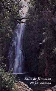 There
are six mountain ranges on the Dominican side of the island, three major and
three minor ones. The northernmost is the vast Cordillera Central (it occupies
nearly half of the Dominican territory), which begins in Haiti and cuts across
the island before it turns south, to end near San Cristóbal, just west of the
Capital. The mountains of the Cordillera Central include Pico Duarte,
which, at 3,175 meters, is the highest in altitude in all of the Caribbean--Pico
Duarte is a favorite destination for hardy mountain climbers. The
Cordillera Septentrional begins at Monte Cristi's distinctive butte-like
formation called El Morro and runs 180 kilometers along the north coast parallel
to the Cordillera Central, separating the valley of the Cibao from the Atlantic
Coastal Plain. The highest mountain in this chain is Pico Diego de Ocampo, at
1,249 meters. The mountain range breaks briefly where the Cibao opens into
the Atlantic at Nagua, but appears again to form the 546-meter-high peaks of the
Peninsula of Samaná. The eastern mountain range, the Cordillera Oriental, is
the smallest of the three major ranges; it is comprised of the Sierra de Yamasá,
Los Haitises, and the Cordillera Central proper. It borders the Llanura
Oriental, the vast eastern plains that encompasses nearly 14% of the country's
total land area--it is here in the southeast, along the Caribbean Sea, that the
largest tourist resorts are located. The other three mountain ranges are
minor ones, the Sierra de Bahoruco in the south and the Sierra Martín García
to its east, surrounding the Bay of Neyba. Just north of the Sierra de
Bahoruco is the Sierra de Neiba. In between the two is a unique arid
region known as the Hoya de Enriquillo, with its desert dunes and highly
concentrated salt lake (its surface is 40 meters below sea level). The
unusual flora here include a stunning variety of flowering cacti and rare fauna
such as crocodiles and iguanas, beautiful pink flamingos, and other exotic
waterfowl. In between the Neiba range and the Cordillera Central is the
beautiful Valle de San Juan, an 80-kms-long miniature of the Cibao.
There
are six mountain ranges on the Dominican side of the island, three major and
three minor ones. The northernmost is the vast Cordillera Central (it occupies
nearly half of the Dominican territory), which begins in Haiti and cuts across
the island before it turns south, to end near San Cristóbal, just west of the
Capital. The mountains of the Cordillera Central include Pico Duarte,
which, at 3,175 meters, is the highest in altitude in all of the Caribbean--Pico
Duarte is a favorite destination for hardy mountain climbers. The
Cordillera Septentrional begins at Monte Cristi's distinctive butte-like
formation called El Morro and runs 180 kilometers along the north coast parallel
to the Cordillera Central, separating the valley of the Cibao from the Atlantic
Coastal Plain. The highest mountain in this chain is Pico Diego de Ocampo, at
1,249 meters. The mountain range breaks briefly where the Cibao opens into
the Atlantic at Nagua, but appears again to form the 546-meter-high peaks of the
Peninsula of Samaná. The eastern mountain range, the Cordillera Oriental, is
the smallest of the three major ranges; it is comprised of the Sierra de Yamasá,
Los Haitises, and the Cordillera Central proper. It borders the Llanura
Oriental, the vast eastern plains that encompasses nearly 14% of the country's
total land area--it is here in the southeast, along the Caribbean Sea, that the
largest tourist resorts are located. The other three mountain ranges are
minor ones, the Sierra de Bahoruco in the south and the Sierra Martín García
to its east, surrounding the Bay of Neyba. Just north of the Sierra de
Bahoruco is the Sierra de Neiba. In between the two is a unique arid
region known as the Hoya de Enriquillo, with its desert dunes and highly
concentrated salt lake (its surface is 40 meters below sea level). The
unusual flora here include a stunning variety of flowering cacti and rare fauna
such as crocodiles and iguanas, beautiful pink flamingos, and other exotic
waterfowl. In between the Neiba range and the Cordillera Central is the
beautiful Valle de San Juan, an 80-kms-long miniature of the Cibao.
The valley of the Cibao averages between 16 kms and 24 kms in width and stretches across a length of 240 kms. The central portion is known as La Vega Real and is the richest agricultural land on an island where most of the soil is rich and fruitful.
Many of the primary rivers of the country are navigable: the Ozama, Soco, Higuamo, Yaque del Norte, Yaque del Sur, Yuna, Yuma and the Bajabonico. At the source of the Yuna is a great man-made lake and national park, La Presa. Many of the high-mountain rivers have beautiful cascading waterfalls.
The Dominican Republic has rain-forested slopes, high treeless plains, and along the island's shore, there are mangrove jungles, phosphorescent bays, caves and sinkholes of all sizes and description, and palm-lined beaches of golden sand, white sand, gray sand, and black sand, as well as many beaches to the west with no sand at all, just rocks and gravel of all colors imaginable.
Many
tourists know the beaches of Hispaniola--but there is so much more! It is
the most geographically diverse island in the entire Caribbean chain.
(CLIMATE)
(Special
Notes)